

Case studies / Risk intelligence · United Kingdom
Dragonfly.
Intelligence with a geographic perspective.
A connected platform for exploring risk, researching locations and working with intelligence. Customer tools and analyst workflows bring maps, structured data and publishing into one delivery platform.
Discuss a similar project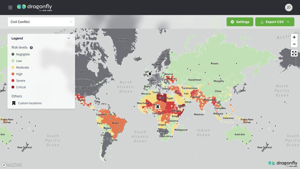
The challenge
Connect research.
Keep the context.
Risk intelligence combines structured ratings, geographic locations, events and research. Customers need to move between an overview and the detail behind it, while analysts need tools to maintain and publish the underlying information.
The platform brings those responsibilities together through a customer website, analyst administration tools and distinct backend services. Delivery work has also supported platform consolidation through an acquisition.
The product
From the world view
to the working detail.
Interactive maps connect country and location risk ratings to geographic context. Users can change risk categories, inspect legends, manage custom locations and export structured information.
Research, threat-event views, tables and charts complement the maps. The analyst application provides the administrative workflows behind the customer experience.
Mapbox renders native light and dark basemaps, while risk colours and map controls retain their meaning in both styles.
The engineering
Geospatial intelligence.
A cloud delivery platform.
Customer-facing research tools and an analyst administration application share a service-based backend. The cloud platform handles spatial data, access, publishing and scheduled data operations.
- Customer & analyst UIReact · TypeScript · Remix
Mapbox maps and analysis tools - API entryAPI proxy · Cloud Endpoints / ESPv2
Authenticated service requests - Domain servicesCore · Authentication · Product
Python APIs on Cloud Run - Intelligence dataCloud SQL · PostgreSQL / PostGIS
Spatial records and research content
Technology & infrastructure
| Application | React · TypeScript · Remix · Tailwind · Ant DesignCustomer research experiences and analyst administration workflows. |
|---|---|
| Maps & analysis | Mapbox GL · react-map-gl · Turf · AG Grid · RechartsGeographic visualisations, spatial interactions, searchable analyst tables and charts. |
| Services | Python · Flask · SQLAlchemy · MarshmallowCore, Authentication and Product services divide data, identity and product responsibilities. |
| Data & assets | PostgreSQL · PostGIS · Cloud SQL · Cloud StorageRelational and geographic data alongside cloud-hosted assets. |
| Cloud & automation | Google Cloud Run · Cloud Scheduler · Cloud Run jobsContainerised applications and scheduled import / export processing. |
| Delivery & configuration | GitLab CI · Cloud Build · Terraform · Secret ManagerContainer delivery, a versioned cloud foundation, environment configuration and managed runtime secrets. |
Preproduction and production have separate environment configurations. Terraform and the infrastructure configuration generator define the cloud foundation; delivery pipelines build and deploy the application services.
Scheduled jobs support data imports and exports. Cloud Logging and Sentry provide diagnostics across the platform.
From the client
One of their strengths is quickly building out a multi-disciplinary team to work on the development and delivery of features with different technical requirements. Their support has allowed us to accelerate our development work without building an internal team. They have also worked seamlessly with other third parties both during the acquisition of Dragonfly and development of our mobile app.
Build with Cloudini
Make complex information
easier to work with.
Talk to us about data platforms, geographic tools and the cloud infrastructure behind them.
Tell us what you are building